
Hidden Utah Beauties
Everyone is familiar with Zion, Arches and Bryce Canyon. But there are tons of hidden gems throughout Utah that offer similar views for a cheap and less commercialized experience. While you’re making your way through the greats, don’t forget to add some of these to your hiking list.
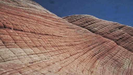
Yant Flat (Aka. The Candy Cliffs)
Yant Flat is a free 3.5-mile round trip hike in the Dixie National Forest north of St. George Utah. The trail is sandy but easily accessible. The day we hiked this trail, it was hot. Which may have accounted for us being the only ones there. Either way, the hike is less known about which offers some great peace and quiet to contrast nearby Zion National Park. At the end of the trail, you’ll find plenty of “candy cliffs”. The bright orange walls offer a sort of creamsicle vibe. This, of course, didn’t help my constant popsicle craving during the hottest of hikes.
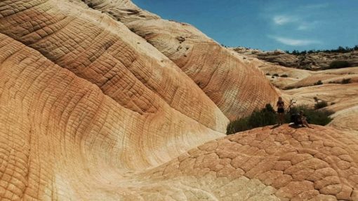
Regardless, if you have time to kill in the St. George area, add Yant Flat to your to-do list. Many people refer to this as Utah’s version of “The Wave” a popular place in Arizona which is difficult to obtain a permit for.
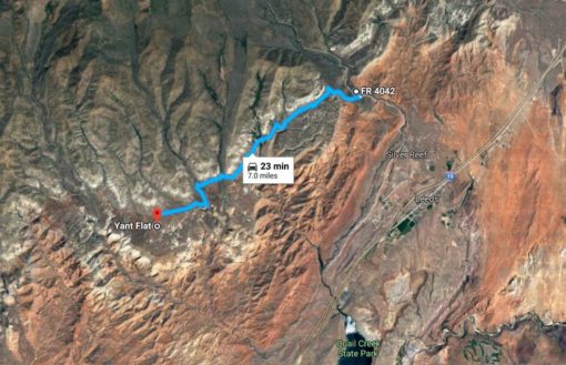
Bonus: If you’re boon-docking there’s a nice area about 20 minutes down the road. You can see the orange colors here in this satellite photo. The boon-docking site coordinates on FR 4042 are 37.272924, -113.38857.
Sand Hollow State Park
Ok, you got me, this is a park. But it’s a state park, and much less popular than the national parks around it. Sand Hollow is a small reservoir near Zion, with great places for cliff jumping and swimming. If you have a boat, this is a great place for water sports. We didn’t have a boat, but we found a nice spot to swim and cliff jump. It was 104 degrees when we arrived, so the water was fantastic. The blue water really compliments the red sandstone, so even if you don’t plan on swimming, it makes a great view for a picnic. Entrance fees were $15 per vehicle, but the experience was definitely worth it.
Corona Arch
One of the biggest misconceptions is that Corona arch is in Arches National Park; It’s not. But it’s not far outside Moab either. You may have heard of the infamous swings off this arch, unfortunately, the city has since banned these, but Corona is still worth a visit. To get there you drive an hour from Moab along the Colorado River (spot the petroglyphs on the right-side rock wall if you can), and then hike 1.5 miles to the over 100-foot arch (3 miles round-trip). Its only partly freestanding, which allows for the more adventurous type to climb up a wall just past the arch and walk over to stand on top of the arch. I can’t speak to the legality of this though so climb at your own risk. There’s much less traffic here since it’s not in the national park, which is a huge pro for this arch. In addition, the “No Fly Zone” for drones in National Parks doesn’t apply here. We flew up and through the arch for some great shots. The trail is clearly marked with green paint footprints, and the only confusing part can be at the beginning. When you reach the train tracks although it can be tempting to walk down the tracks through the canyon. Instead, cross over the tracks and you’ll find an open section of the fence. Walk through this, and continue around the walls until you find the green footprints.
This is the location of the trail-head: 38.5748, -109.632

Here you can see my boyfriend standing on top of the arch from where he flew his drone.
Lower Calf Creek Falls
This place is a must. Lower Calf Creek Falls is located near Capitol Reef National Park in the Grand Staircase-Escalante National Monument area. The waterfall is 126 feet of beauty. The hike is 6 miles round-trip, but easy and totally worth it. We were lucky enough to be at the falls for an entire hour by ourselves. We passed quite a few people on the way there but chose to hike in the later hours right before sunset which gave us the oasis all to ourselves. It was a bit rainy so the water was cold, but I can imagine would be super refreshing on a hot day. We hiked in July, wary that the hot weather may have reduced the fall to a trickle, but were thrilled to see it rushing so violently. The hike was long, but the trail goes through the canyon along the creek which offered some great views.


The coordinates for the trail-head are 37.7960333, -111.4136667.
Kanarraville Falls
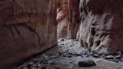
The Kanarraville Creek Trail is about an hour north of Zion National Park from the south entrance, before Cedar City. It requires an $8 hiking permit you purchase at the trail-head. Parking is free, but its hard to pass The Sweet Spot, a snack and ice-cream shack at the front of the parking lot, without opening your wallet. They also sell really cute t-shirts, stickers and iron-on patches. The hike is fairly moderate and requires you to walk through the creek quite often so I recommend Chaco’s or water shoes. Be prepared though, the water is cold. The hike begins up a small paved road, which turns into a dirt road that leads down to the creek. You walk through the creek for a while, but you’ll know you’re nearing the cascades when you reach the slot canyons. The trail leads through a series of slot canyons and in order to continue you must climb some tree ladders.
.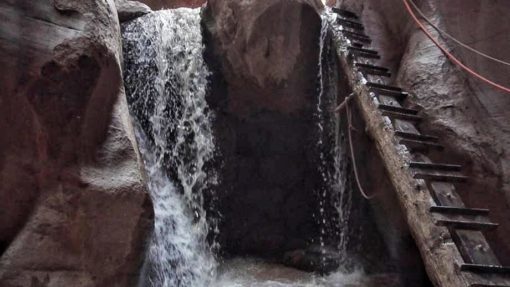
Pictured is the first ladder. Ropes along the wall help for stability. It’s about 10 feet tall.
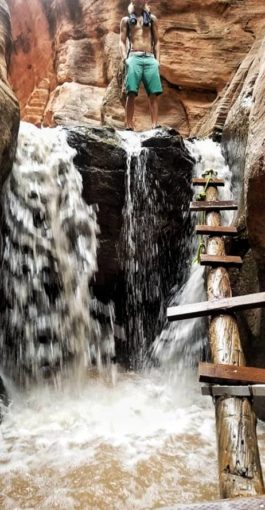
Most people turn around at the 2nd ladder. It’s a bit ricketier than the first, but there’s not much to see beyond it anyway. The farther you go the deeper it will get. Just before the 2nd ladder I was waist deep and had to pick up my backpack above the water. However, a majority of the hike the water is hardly ankle deep. There’s no true destination, so hike as far as you want, but make sure you at least get to the first waterfall and ladder.
For more blogs like this:
5 thoughts